
Precision Ag Ireland
Farm Works has released Version 2012. Some of the major additions to the office solutions include:
Harvested Crop Sales Contracts - Enter contracts and print reports to better manage the position of your unsold crops as well as to manage delivery on contracts.
Variety Layer - Converts planting data into polygons so that these maps can be sent out to variety locator features on supported displays including the Trimble® FmX.
Yield Variety Report - Enables you to take a yield map and merge it with the variety layer to better understand which varieties performed better.
Copy of Attributes for Lines, Polygons, and Points - Allows the ability to copy attributes of a line, polygon, and point from one layer to another.
Support for Trimble FmX variety locator
3D Drainage Design and Verification Capability - Layout and design drainage tile by size, pipe type, phase, then enter the minimum depth, maximum depth, and optimum grade for each. Make adjustments based on profile view as needed and set and change water outlet direction.
To view additional features in Version 2012, please click here.
To download version 2012, click here. This download provides a complete office install for Trac, Funds, Stock, Site, Pro, and Surface. In order to download the latest version, you must be subscribed to the Update Service Plan (USP). If you are not subscribed to the USP, you can order one by contacting Precision Ag Ireland at 0504 42228
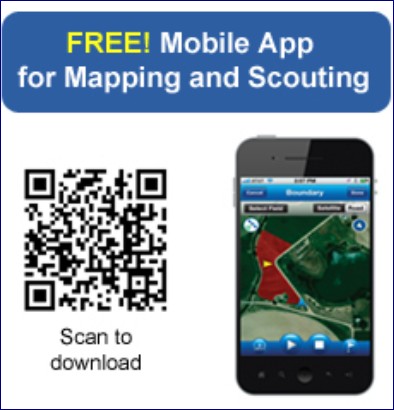
Use the free Connected Farm app on your smartphone to map field boundaries, flag points of interest, and enter scouting information. Scouting attributes include an extensive list of weeds, insects and diseases, and allows you to log the severity of a problem, crop conditions, and more. Also capture photos of pests and integrate them into your scouting notes. All data is sent via cell or Wi-Fi connection to Connected Farm where you can view and analyze data online.
Calculate areas (acres or hectares) and map field boundaries.
Enter scouting attributes for pests, weeds or diseases and log the severity of problems and crop conditions.
Switch between logging paths, points, and polygon areas.
Capture and geo-reference digital images of pests using the phones built-in camera and GPS.
Manages your data by client, farm, and field names.
View and analyze your collected mapping and scouting data from the online viewer.